Bluespire: Difference between revisions
Jump to navigation
Jump to search
imported>Sanddh mNo edit summary |
imported>Arkalor m ToC fix |
||
| (24 intermediate revisions by 4 users not shown) | |||
| Line 1: | Line 1: | ||
{|border=0 align=right | {|border=0 align=right cellpadding=5 | ||
|align=center| [[File:Bluespire Sign Live.jpg|right]] | |align=center| [[File:Bluespire Sign Live.jpg|right]] | ||
|- | |- | ||
|align=center| __TOC__ | |align=center| __TOC__ | ||
|} | |} | ||
''"In 12 PY, the Virindi-altered human Candeth Martine opened the way to Marae Lassel. Soon humans from the mainland came to the island and began to settle. One of these settlements is Blue, a town in the marshlands of the Karab Delta. In Thistledown of 16 PY, as part of Varrici II's war against the "Bloodless, " the three human settlements on Marae were captured under cover of night. Though a fragile truce now exists between Strathelar and Varrici, the three spire towns remain under New Viamont's control." --[[Bluespire (Town Network Sign)|Town Network Sign]]'' | |||
* One of the three smaller Isparian towns, located on the southern end of the [[Karab Delta]] on [[Marae Lassel]] at 39.4N 75.4W. | |||
* Discovered during the [[Dark Majesty]] event, Isparian Shopkeepers took up residence here, together with the native inhabitants, the Aun Tumerok. | |||
* Like [[Redspire]] and [[Greenspire]], it was invaded by the [[Viamontian]]s during the [[Under Cover of Night]] event. | |||
* The Viamontians immediately started building strongholds, such as the tower in the middle of town. | |||
{| | |||
|{{Map Point|39.4|N|75.4|W|Marker=Via Town|Show Towns=False}} | |||
|} | |||
{{Map Point|39.4|N|75.4|W|Marker=Town}} | |||
== Portals == | == Portals == | ||
| Line 17: | Line 20: | ||
| Table Rows = | | Table Rows = | ||
{{Portal Row | {{Portal Row | ||
| Location = | | Location = Town Network | ||
| LocCoords = | | LocCoords = Annex (South) | ||
| Destination = Holtburg | |||
| DestCoords = 39.5N, 75.3W | |||
| Restrictions = None | |||
| Destination = | |||
| DestCoords = 39. | |||
| Restrictions = | |||
}} | }} | ||
}} | }} | ||
| Line 51: | Line 33: | ||
| Table Rows = | | Table Rows = | ||
{{Portal Row | {{Portal Row | ||
| Location = Bluespire | | Location = Bluespire | ||
| LocCoords = | | LocCoords = 39.4N, 75.4W | ||
| Destination = | | Destination = Town Network | ||
| DestCoords = | | DestCoords = | ||
| Restrictions = | | Restrictions = None | ||
}} | }} | ||
{{Portal Row | {{Portal Row | ||
| Location = Bluespire | | Location = Bluespire | ||
| LocCoords = | | LocCoords = 40.0N, 74.5W | ||
| Destination = | | Destination = Northern Manumet Plains | ||
| DestCoords = | | DestCoords = 50.5N, 68.2W | ||
| Restrictions = | | Restrictions = 25+ | ||
}} | }} | ||
}} | }} | ||
== Points of Interest == | == Points of Interest == | ||
=== Landscape POIs === | === Landscape POIs === | ||
* 41.9N 77.6W - [[Marescent Plateau Portal]] | * 41.9N, 77.6W - [[Marescent Plateau Portal]] | ||
* [[40.5N, 78.2W - Tumerok Camp]] | * [[40.5N, 78.2W - Tumerok Camp]] | ||
=== Lifestones === | === Lifestones === | ||
* 39.3N, 75.3W - Town Center | * 39.3N, 75.3W - Town Center | ||
* 41.0N 77.4W | * 41.0N, 77.4W | ||
=== Dungeons === | === Dungeons === | ||
| Line 89: | Line 63: | ||
| Coordinates = 38.9N, 76.3W | | Coordinates = 38.9N, 76.3W | ||
| Wiki Map File = | | Wiki Map File = | ||
| ACmaps ID = | | ACmaps ID = 0287 | ||
| | | Related Quests = [[Raeta's Necklace Quest]] | ||
}} | }} | ||
{{Dungeon Maps | {{Dungeon Maps | ||
| Line 97: | Line 70: | ||
| Coordinates = 39.4N, 75.3W | | Coordinates = 39.4N, 75.3W | ||
| Wiki Map File = | | Wiki Map File = | ||
| ACmaps ID = | | ACmaps ID = 0068 | ||
| | | Related Quests = [[Plateau Village Transit]] | ||
}} | }} | ||
}} | }} | ||
| Line 281: | Line 253: | ||
[[Category:Town]] | [[Category:Town]] | ||
Latest revision as of 18:33, 10 March 2013
 |
"In 12 PY, the Virindi-altered human Candeth Martine opened the way to Marae Lassel. Soon humans from the mainland came to the island and began to settle. One of these settlements is Blue, a town in the marshlands of the Karab Delta. In Thistledown of 16 PY, as part of Varrici II's war against the "Bloodless, " the three human settlements on Marae were captured under cover of night. Though a fragile truce now exists between Strathelar and Varrici, the three spire towns remain under New Viamont's control." --Town Network Sign
- One of the three smaller Isparian towns, located on the southern end of the Karab Delta on Marae Lassel at 39.4N 75.4W.
- Discovered during the Dark Majesty event, Isparian Shopkeepers took up residence here, together with the native inhabitants, the Aun Tumerok.
- Like Redspire and Greenspire, it was invaded by the Viamontians during the Under Cover of Night event.
- The Viamontians immediately started building strongholds, such as the tower in the middle of town.
Portals
To Bluespire
| Location | Coords | Destination | Coords | Restrictions |
| Town Network | Annex (South) | Holtburg | 39.5N, 75.3W | None |
From Bluespire
| Location | Coords | Destination | Coords | Restrictions |
| Bluespire | 39.4N, 75.4W | Town Network | -- | None |
| Bluespire | 40.0N, 74.5W | Northern Manumet Plains | 50.5N, 68.2W | 25+ |
Points of Interest
Landscape POIs
- 41.9N, 77.6W - Marescent Plateau Portal
- 40.5N, 78.2W - Tumerok Camp
Lifestones
- 39.3N, 75.3W - Town Center
- 41.0N, 77.4W
Dungeons
| Dungeon | Coordinates | Wiki Map | ACmaps | Other | Quests |
| Aun Papileona's Shrine to Raeta | 38.9N, 76.3W | -- | 0287 | -- | Raeta's Necklace Quest |
| Viamontian Laboratory | 39.4N, 75.3W | -- | 0068 | -- | Plateau Village Transit |
NPCs
| NPC Name | Location | Type | Details |
| Brother Ku-Xao Sutan the Monk | 39.5N, 75.2W | Shopkeeper | Parchment and Books |
| Dorlan the Armorer | 39.2N, 75.5W | Shopkeeper | Aluvian Weapons and Armor |
| Lark Grifanna the Barkeep | 39.2N, 75.0W | Shopkeeper | Food, Drinks, and Rumors |
| Lucarus Malloni the Armorer | 39.1N, 75.4W | Shopkeeper | Viamontian Weapons and Armor |
| Nathious Agoren the Jeweler | 39.0N, 75.3W | Shopkeeper | Gems and Jewelery |
| Wahnaqa bint Fayat the Mage | 39.2N, 75.2W | Shopkeeper | Magical Supplies |
| Yusnar ibn Lomaq the Grocer | 39.5N, 75.5W | Shopkeeper | Food and Cooking Supplies |
| Aurten Rhell | 39.5N, 75.5W | Quest | Refulgent Bracelet |
| Aun Papileona | Outskirts - 39.8N, 76.4W | Quest | Raeta's Necklace Quest |
| Aun Teriona | Outskirts - 41.3N, 75.3W | Quest | Carenzi Plague |
| Aun Arenura the Crafter | 39.2N, 75.0W (2nd Floor) | Crafter | Siraluun Dresses |
| Aun Ihmenaura | 39.7N, 75.3W | Crafter | Artisan in Feather and Claw |
| Aun Kahuiura | 39.7N, 75.3W | Crafter | Artisan in Arcane Ointment |
| Aun Pitamaura | 39.7N, 75.3W | Crafter | Artisan in Spike and Blade |
| Aun Nireeura | 39.7N, 75.3W | Crafter | Artisan in Pin and Pitch |
| Merlonna Farel the Collector | 39.5N, 75.5W | Crafter | -- |
| Otto Selino | 39.4N, 75.3W | Miscellaneous | Astronomer |
| Salvito di Marden | 39.2N, 75.3W | Miscellaneous | Ferran Knight |
| Town Crier | 39.4N, 75.4W | Miscellaneous | -- |
| Turino Ribini | 39.2N, 75.2W | Miscellaneous | Tax Collector |
| Vettorio Bilcone | 39.4N, 75.3W | Miscellaneous | Ferran Knight |
Creatures
Creatures that are commonly found in the area surrounding Bluespire.
Art & Images
-
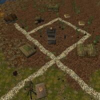
Overview on Bluespire


